Archive Record
Images
Metadata
Title |
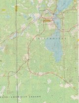
Rail lines in the Winchester area. circa 1910 |
Scope & Content |
This standard U.S.G.S. topographic map was annotated by civil engineer and railroad historian James P. Kaysen to show the location of existing and defunct rail lines around the communities of Winchester and Manitowish Waters. Kaysen enhanced about 1,200 maps this way, typically drawing rail lines in red ink and adding statistical and historical information about lumber companies and railroads in the margins. This section of the map shows the rail lines in the Winchester/Turtle Lake area. Date annotated: 1981 Source: Wisconsin Historical Society URL:http://content.wisconsinhistory.org/cdm/singleitem/collection/maps/id/3144/rec/38 Digital ID: none Image ID: none Page #:1 |
Date |
circa 1910 |
Source |
Wisconsin Historical Society Wisconsin Historical Society |
Collection |
Maps |
Catalog Number |
2018.1.33R |
Object Name |
Map |
Search Terms |
Maps Railroads Wisconsin HIstorical Society 1910 Northern rail routes Logging Winchester Flambeau Lumber Company Turtle Lake Lumber Company Chicago North Western Railroad railroad |
Subjects |
Logging railroads maps |