Archive Record
Images
Metadata
Title |
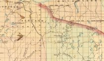
Earliest rail connection to Fifield and Park Falls to gain river access to the MW area. 1874 |
Scope & Content |
Asher & Adams' 1874 map cropped to highlight northern Wisconsin. The map shows early railroad lines when the northern third of the state was just beginning to develop with railroads reaching the infant cities of Superior, Bayfield and Ashland. These railroads were used to gain river access to the Manitowish Waters and surrounding areas. Source: Wisconsin Historical Society George S Parker Map Collection URL: http://content.wisconsinhistory.org/cdm/singleitem/collection/maps/id/248/rec/19 WHI Image ID 73172 |
Date |
1874 |
Source |
Wisconsin Historical Society Wisconsin Historical Society |
Collection |
Maps |
Catalog Number |
2018.1.2R |
Object Name |
map |
Search Terms |
Railroads Maps Logging railroad |
Subjects |
Logging Railroads Maps |