Archive Record
Images
Metadata
Title |
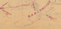
Earliest map of rail line from Powell depot to Little Star and Manitowish Lakes. 1900 |
Scope & Content |
This is a segment of the map titled "Lakes Tributary to G.W. Buck and Son Resorts" hand drawn by Fayette (Fay) Buck in 1900. This map illustrates the earliest rail line from the town of Powell, by today's Highway 47, to Little Star and Manitowish Lakes where logs were loaded onto rail cars and visitors to the area were dropped off to get launches to area resorts. This map dates the existence of the railroad spur at 1900. The map also shows the Manitowish Depot, phone lines and resorts Source: Wisconsin Historical Society URL: https://www.wisconsinhistory.org/Records/Image/IM97107 Digital ID: 97107 Image ID: GX9028 V69 1900 B 1903Page #:1 |
Source |
Wisconsin Historical Society Wisconsin Historical Society |
Collection |
Maps |
Catalog Number |
2018.1.14R |
Object Name |
Map |
Search Terms |
Maps Railroads Northern rail routes Logging Powell depot Little Star Lake Buck's Spider Lake Resort Manitowish Lake railroad |
Subjects |
Logging railroads maps |