Archive Record
Images
Metadata
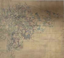
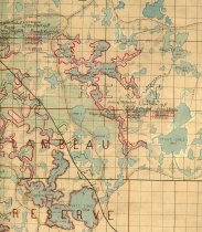
Title |
Map showing the effect proposed logging dams would have on water levels of the lakes in the upper Flambeau River watershed. ca 1879 |
Scope & Content |
The red line demonstrates the raised water levels. This map was procured by Mark Leistickow and donated to the Town of Manitowish Waters/Koller Library in 2014. |
Date |
ca 1879 |
Source |
Frank Koller Memorial Library |
Collection |
Logging Collection |
Catalog Number |
2018.5.147 |
Object Name |
Map |
Search Terms |
dams water levels Chain of lakes, Manitowish Waters Flambeau River Logging Manitowish Chain Maps Rest Lake Dam river drives 1870s |
People |
Leistickow,Mark |
Subjects |
Maps Lakes & ponds Rivers Dam construction Dams Logging |