Archive Record
Images
Metadata
Title |
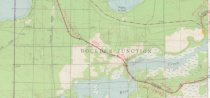
Map showing rail line where Rice Creek Depot was located. circa 1910 |
Scope & Content |
This standard U.S.G.S. topographic map was annotated by civil engineer and railroad historian James P. Kaysen to show the location of existing and defunct rail lines around the community of Katinka Village (Papoose Lake Quadrangle). Kaysen enhanced about 1,200 maps this way, typically drawing rail lines in red ink and adding statistical and historical information about lumber companies and railroads in the margins. This section of the map shows the Milwaukee and St.Paul Rail line from Boulder Jct to Papoose Jct/Buswell Lumber community where it crosses Rice Creek between Big Lake and Island Lake. Location of the Rice Creek depot. Date annotated: 1981 Description: Source: Wisconsin Historical Society URL:http://content.wisconsinhistory.org/cdm/singleitem/collection/maps/id/2786/rec/19 Digital ID: none Image ID: none Page #:1 |
Date |
circa 1910 |
Source |
Wisconsin Historical Society Wisconsin Historical Society |
Collection |
Maps |
Catalog Number |
2018.1.24R |
Object Name |
Map |
Search Terms |
Maps Railroads Northern rail routes Logging Rice Creek station railroad |
Subjects |
Logging railroads maps |