Library Record
Images
Metadata
Notes |
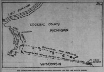
"Engineer's Error By Which Michigan Lost & Wisconsin Gained Part of Iron Range" 11/27/1914 |
Summary |
Capt. T.J. Cram selected the wrong terminus for establishing the boundary line between the two states. The result was Wisconsin gained 600 square miles of mineral rich territory. This line was disputed for many years. A Norway pine tree with a blaze from this surveyor's expedition was found along the shore of Trout Lake. |
Collection |
Government |
Media Link |
Click here to read page 1 of the article. Click here to read page 2 of the article. |
Source |
Collected or Produced by Staff |
Catalog Number |
2023.001.038 |
Published Date |
11/27/1914 |
Author |
C.H. Kelsey |
Search Terms |
1840s 1900s Boundary line Wisconsin Michigan Iron Range Lac Vieux Desert Montreal River Menominee River Trout Lake Wisconsin Headwaters Country Wisconsin HIstorical Society Solar compass |
People |
Cram, Thos J. Houghton, Douglas, Dr. Mann, John B. Lloyd, M.W. Carigan, Charles Nolan, A. Burt, W.A. |