Archive Record
Images
Metadata
Title |
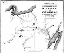
A report by Thos. Cram to ascertain the boundary line between "the State of Michigan and the Territory of Wiskonsin". 1840 |
Scope & Content |
A report written by Captain Thos. J. Cram (aka Th. Jefferson Cram) in 1840 printed in "Message from the President of the United States in compliance with a resolution from the Senate in relation to the survey to ascertain and designate the boundary line between the State of Michigan and the Territory of Wiskonsin" . This survey was directed to be done by the 6/12/1838 act of Congress. This report includes an account of Cram's survey route, encounters with Native Americans near Lac Vieux Desert, maps, survey details and observations and his conclusions. |
Date |
1940 |
Media Link |
Click here to view the report. |
Source |
MWHS Research Files-Logging |
Collection |
Logging Collection |
Catalog Number |
2019.5.8 |
Object Name |
Report |
Search Terms |
Wisconsin boundary surveyors Lac Vieux Desert gardens maple sugar guides Chippewa Ojibwa Montreal River Lac du Flambeau fur trading French voyageurs potatoes |
People |
Chief Ca-sha-o-sha Cram, Thos J. |
Subjects |
Surveyors Surveying Maple sugar industry Fur trade Rivers Indian reservations |